信息
“智闻AI“ 是由人工智能编撰的刊物集合,确保您只获得最有价值的信息,旨在助您消除信息差,突破信息茧房的局限。 了解更多 >>
美国宇航局利用先进工具绘制巴西南部洪水影响区域
- summary
- score

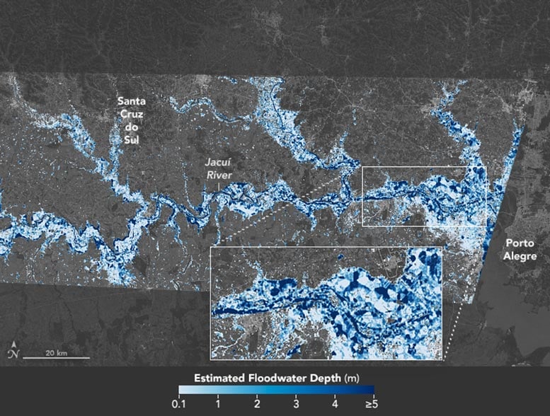
2024年,洪水肆虐巴西南部,特别是南里奥格兰德州。美国宇航局利用先进工具,绘制了这场灾难的深度地图。该地图对于救援工作和经济评估至关重要,详细记录了2024年5月6日的淹没范围。
地图显示了水深超过5米的区域,与0.1至1米的浅水区形成对比。这种精确性有助于救援行动、道路封闭和损害分析。美国宇航局喷气推进实验室的研究员Dinuke Munasinghe强调了洪水对家庭和生计的重大影响。
通过使用洪水深度估计工具(FwDET),该工具整合了卫星图像和地形数据,美国宇航局提供了可行的见解。这一工具在其他洪水事件中也曾使用,对灾害响应至关重要。
美国宇航局的开放地图门户促进了这种支持,提供了灾难的清晰视图。这些地图的精确性突显了科学在灾害管理中的关键作用。
| Scores | Value | Explanation |
|---|---|---|
| Objectivity | 5 | Content provides factual information and uses NASA's data, maintaining a balanced perspective. |
| Social Impact | 4 | Content informs about a significant disaster, influencing public awareness and potential aid responses. |
| Credibility | 5 | Information is sourced from NASA, a reputable scientific organization. |
| Potential | 4 | The use of advanced mapping tools could influence future disaster response strategies. |
| Practicality | 5 | The maps are directly applicable to rescue and recovery efforts in the flood-affected areas. |
| Entertainment Value | 2 | While informative, the content lacks typical entertainment elements. |