"Informed AI News" is a news aggregation platform based on AI, aiming to provide users with high-quality news content that has been carefully selected and organized. It analyzes a vast array of news sources, filtering out low-quality or untrustworthy information to ensure that users receive accurate and timely news. Find out more >>
NASA Utilizes Advanced Tools to Map Flood-Affected Areas in Southern Brazil
- summary
- score
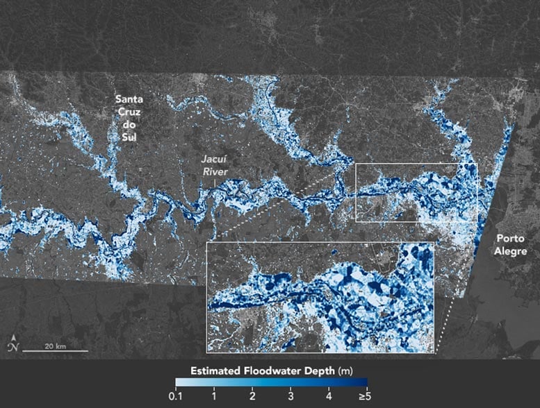
In 2024, floods devastated southern Brazil, particularly Rio Grande do Sul. NASA, using advanced tools, mapped the depths of this disaster. Their map, vital for relief efforts and economic assessments, detailed the extent of the flooding on May 6, 2024.
The map showed areas where water depths exceeded 5 meters, contrasted with shallower areas ranging from 0.1 to 1 meter. This precision is crucial for rescue operations, road closures, and damage assessment. Dinuke Munasinghe, a NASA JPL researcher, highlighted the significant impact on homes and livelihoods.
Employing the Flood Depth Estimation Tool (FwDET), which combines satellite imagery and terrain data, NASA delivered actionable insights. This tool, previously utilized in other flood events, is essential for disaster response.
NASA's open map portal enabled this support, providing a clear view of the catastrophe. The accuracy of these maps emphasizes the vital role of science in disaster management.
| Scores | Value | Explanation |
|---|---|---|
| Objectivity | 5 | Content provides factual information and uses NASA's data, maintaining a balanced perspective. |
| Social Impact | 4 | Content informs about a significant disaster, influencing public awareness and potential aid responses. |
| Credibility | 5 | Information is sourced from NASA, a reputable scientific organization. |
| Potential | 4 | The use of advanced mapping tools could influence future disaster response strategies. |
| Practicality | 5 | The maps are directly applicable to rescue and recovery efforts in the flood-affected areas. |
| Entertainment Value | 2 | While informative, the content lacks typical entertainment elements. |